It is the most common question we get that nobody has an actual number for. A house on the corner sells, a lockbox goes on the door, a rental sign goes in the yard, and the neighbors conclude that an institutional buyer is acquiring the block.
So we stopped guessing and counted. We pulled the county appraisal district bulk rolls, which are public records, for Dallas, Collin and Denton counties. We took every detached single family parcel on each roll. We grouped those parcels by the exact owner name the roll prints, and we counted how many houses each owner holds inside that county.
The number that comes out is smaller than the conversation, and it is much less evenly distributed than the county average suggests. Both of those facts matter, and the second one is the more useful of the two.
One limit belongs in the first paragraph rather than the method section, because the title asks a question this data cannot fully answer. A county share and a ZIP share cannot tell you what any single street looks like. A ZIP running 9.1 percent can contain a block where an owner holds six of forty houses and a block where they hold none, and the roll we used is aggregated to the ZIP, so we cannot see either one.
One thing this post is not: it is not a count of rentals, and it is not a count of purchases. An appraisal roll is a snapshot of who owns what on the day the roll was certified. It does not record why anybody bought anything, when they bought it, or what they do with it.
Key Takeaways
- In Dallas County, owners with ten or more houses hold 2.5 percent of detached single family parcels. That is a county figure and it cannot describe any one street.
- In Collin County it is about one in a hundred. In Denton County, about one in fifty.
- The concentration is not spread evenly. Inside Dallas County the highest shares are 75146 at 9.1 percent, 75210 at 8.8 percent and 75154 at 6.6 percent, while 75205, 75225 and 75039 round to zero and 75231 and 75254 sit at one tenth of one percent.
- A county or ZIP share cannot describe one street. These figures are aggregated to the ZIP code.
- No single roll name in any of the three counties appears on more than a few hundred parcels. Because affiliated entity names were not merged, that is a floor on any operator's true holdings rather than a ceiling.
What We Counted, and What Counts as an Owner
Three definitions carry this entire post, so they go first.
A detached single family parcel is what each county's own class code says it is. In Dallas that is the state property type code A11. In Collin it is a property category code of A with a land type code of A1. In Denton it is a state code of A1. Condominiums, townhomes and duplexes are excluded on all three counties, which means build to rent townhome product does not appear anywhere in these numbers.
An owner is the exact name printed on the roll, uppercased, with punctuation stripped and whitespace collapsed. Nothing was merged. Two entity names that look related were counted as two owners, because a name that looks affiliated is not proof of common control, and we would rather publish a number that is too small than one we cannot defend.
A large owner is an owner name holding ten or more detached single family parcels in that one county. That threshold is a choice, and it is the most consequential choice in the analysis. Most landlords in DFW own one to three houses and are completely invisible at this cutoff. What we are measuring is institutional scale concentration, not the share of houses that are rentals.
One vintage note, because it prevents a bad comparison. Dallas is the 2026 roll, Collin is the 2025 roll, and Denton is the 2027 roll. Those are three different tax years. They are not a like for like snapshot of one moment, and they must not be summed into a single DFW figure.
The Actual Share
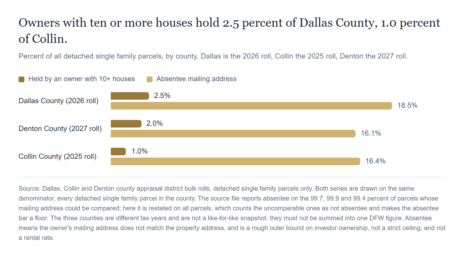
Dallas County carries 512,454 detached single family parcels on its 2026 roll. Owners holding ten or more of them account for 12,709 of those parcels, which is 2.5 percent, spread across 561 such owners.
Collin County's 2025 roll carries 312,168 detached single family parcels, of which 1.0 percent are held by owners with ten or more, across 140 such owners. Denton County's 2027 roll carries 281,441 parcels, 2.0 percent held by owners with ten or more, across 237 such owners.
Read those as three separate counts on three different tax years, not as one metro figure.
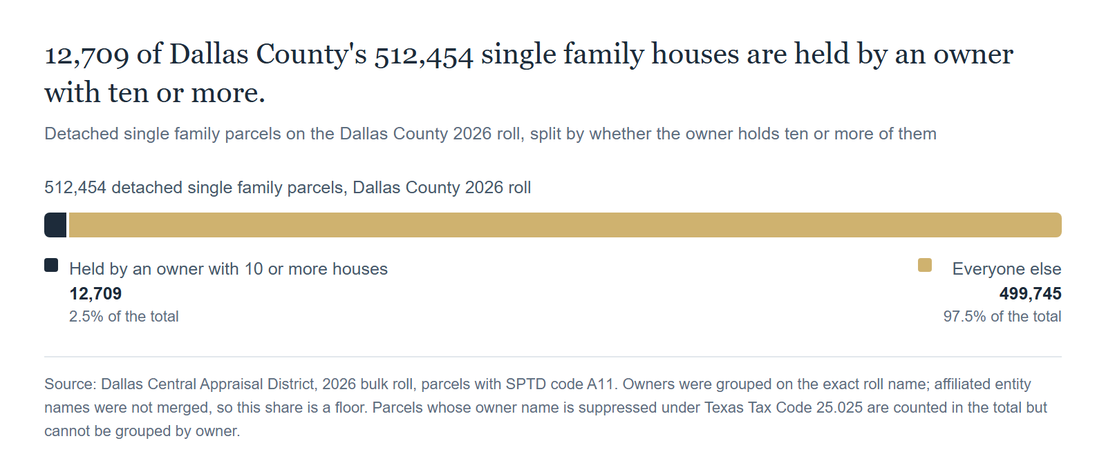
That is the headline, stated plainly: in the county where the concentration we can measure is highest, owners with ten or more houses hold 2.5 percent of detached single family parcels. It is not an answer to the question in the title, because a county share cannot describe any one street.
The same roll also gives a rough outer bound on the broader question, since a mailing address that differs from the property address includes second homes and trusts as well as rentals. Absentee ownership, meaning the owner's mailing address does not match the property address, runs 18.6 percent in Dallas County, 16.4 percent in Collin and 16.2 percent in Denton. Those three are measured on the parcels whose mailing address could actually be compared, which is 99.7, 99.9 and 99.4 percent of each county's parcels. The absentee bar on the chart above is restated on all parcels instead, so it counts the handful of uncomparable parcels as not absentee and sits a fraction of a point lower. Either way it is a rough outer bound rather than a strict ceiling, and it is not a rental rate. Second homes, inherited houses, relocations, owners who mail to a certified public accountant, and anyone whose mailing address has not caught up with a recent purchase all read as absentee. Those are two different measurements with two different definitions, and we publish them separately rather than as a range. The 2.5 percent counts parcels whose roll owner name holds ten or more detached houses in the county. The 18.6 percent counts parcels whose owner mailing address does not match the property address, for any reason. Neither one is an investor share, and this data cannot produce one.
Where the Concentration Actually Sits
The county average hides the thing worth knowing. Within Dallas County, ten ZIP codes carry a share held by owners of ten or more houses that runs several times the county figure, and they are named below with their shares and their parcel counts.
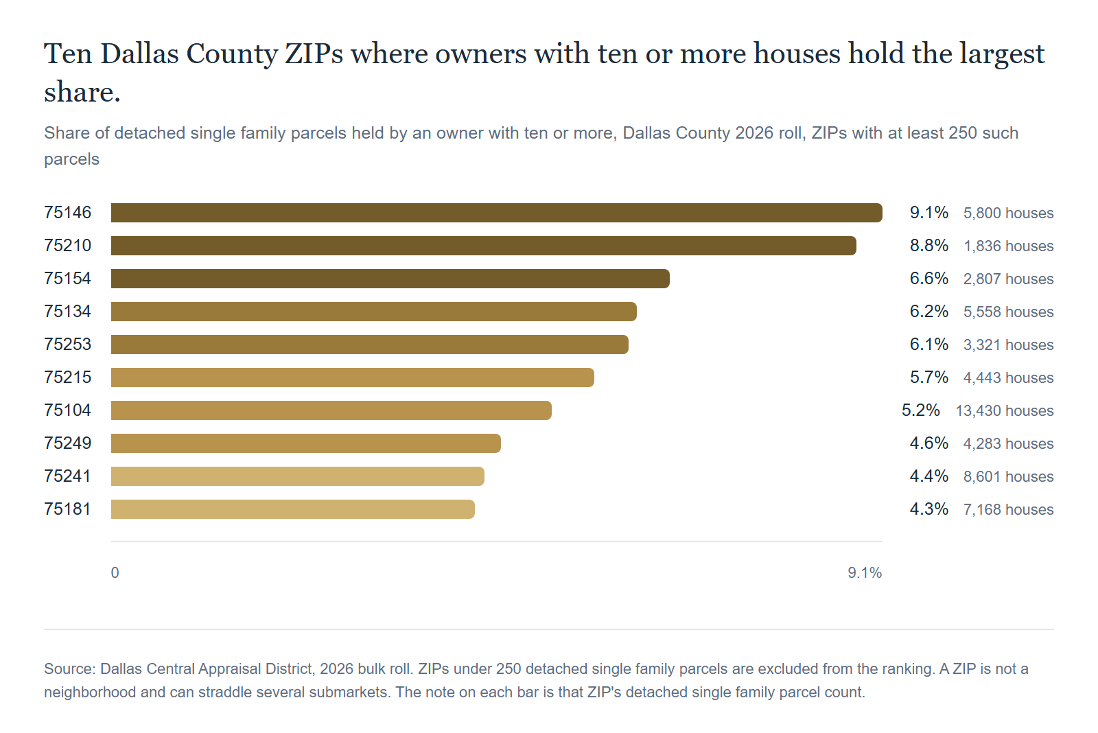
At the top, 75146 in the Lancaster area runs 9.1 percent across 5,800 detached single family parcels. Then 75210 at 8.8 percent on 1,836 parcels, and 75154 at 6.6 percent on 2,807. The rest of the list, 75134, 75253, 75215, 75104, 75249, 75241 and 75181, runs between 4.3 and 6.2 percent, on parcel counts from 3,321 up to 13,430.
Now look at the other end of the same county. In 75225, 75205 and 75039 the share held by owners with ten or more houses rounds to zero. In 75231 and 75254 it is one tenth of one percent. We are not ranking those ZIP codes by price, because this roll extract carries ownership and not value.
That contrast is the most useful finding in this post. In our listing conversations, the question comes up across the county at roughly the same rate, including in the ZIP codes where the measured share rounds to zero. Those ten are the highest shares in the county, not the only ones with a measurable share. Shares continue below them, with 75115 at 4.2 percent and 75203 at 3.75 percent as examples, and even inside the top ten the number is a ZIP average rather than a description of any one street.
Denton County shows the highest single ZIP share we found anywhere in the three counties: 76078, at 9.9 percent on 476 detached single family parcels. Note the denominator on that one. It is a small ZIP, just above our 250 parcel reporting floor, so a share that high rests on a few dozen houses.
Full List, For Reference
The ten highest Dallas County ZIP codes, with each ZIP's own parcel count so you can weigh the share against the base it sits on.
ZIP | Detached single family parcels | Held by owners with 10 or more | Absentee |
|---|---|---|---|
75146 | 5,800 | 9.1% | 23.9% |
75210 | 1,836 | 8.8% | 43.6% |
75154 | 2,807 | 6.6% | 20.2% |
75134 | 5,558 | 6.2% | 23.1% |
75253 | 3,321 | 6.1% | 23.4% |
75215 | 4,443 | 5.7% | 39.5% |
75104 | 13,430 | 5.2% | 21.0% |
75249 | 4,283 | 4.6% | 18.9% |
75241 | 8,601 | 4.4% | 25.6% |
75181 | 7,168 | 4.3% | 24.8% |
Who Owns Them, By Roll Name
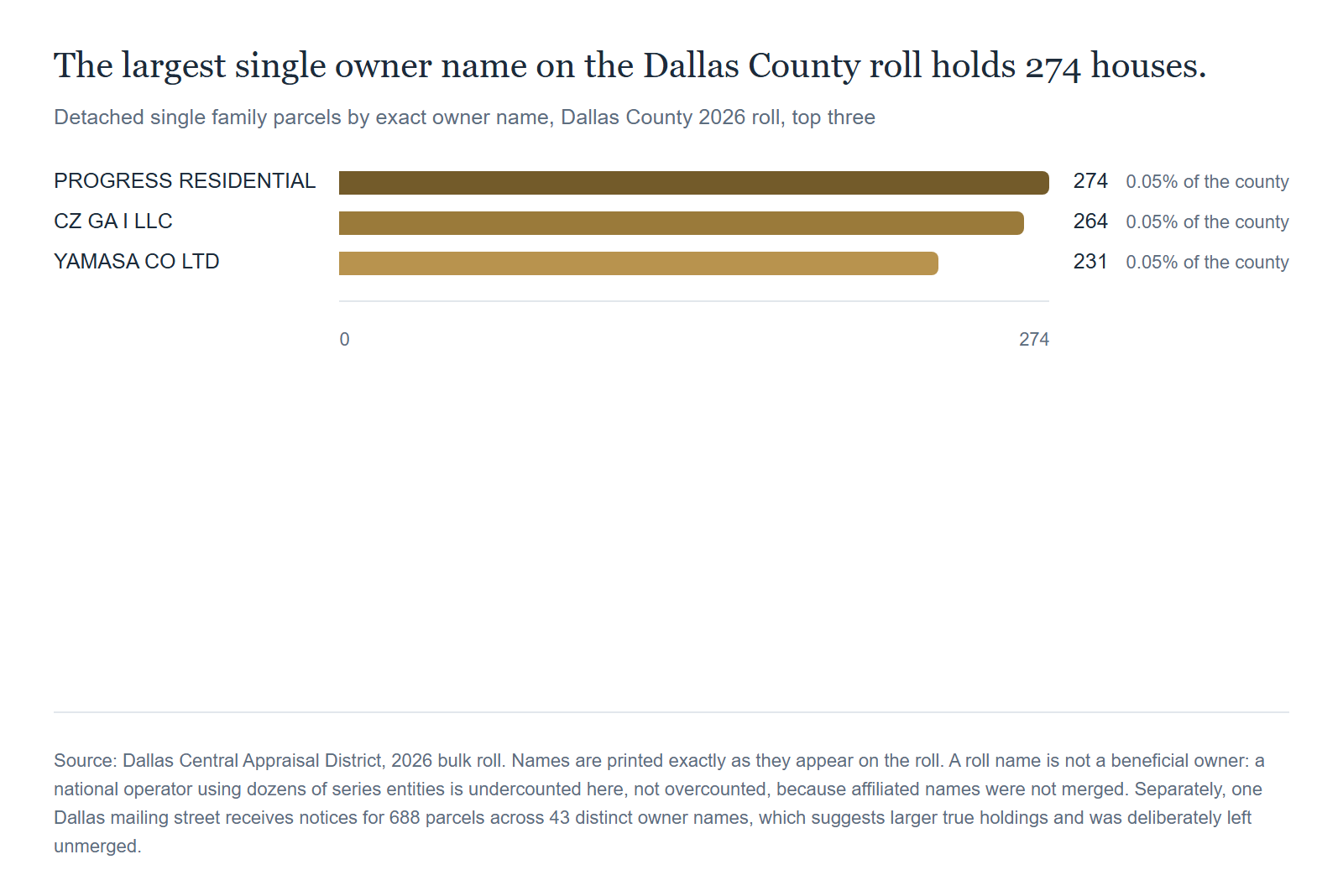
Three names lead the Dallas County roll, printed exactly as the roll prints them. PROGRESS RESIDENTIAL holds 274 parcels. CZ GA I LLC holds 264. YAMASA CO LTD holds 231.
Those are the three largest single names in a county of 512,454 detached houses. The largest of them is roughly five hundredths of one percent of the county. Whatever the institutional single family rental business is doing in Dallas County, no single name on this roll holds more than a few hundred of its houses. That is a countywide statement and not a statement about any one block, because nothing here is aggregated below the ZIP code, so it cannot answer what a single street looks like.
A roll name is also not a beneficial owner. A house held in a family trust, a one off LLC or a title holding entity reads as an institutional owner in a count like this one. Two affiliated LLCs read as two separate owners. A single national operator running dozens of series entities is undercounted here rather than overcounted. Some owner names carry a year, such as 2014 or 2018, which is a naming convention and not proof of common control.
The Mailing Address Problem
Here is the caveat that cuts the other way, and it is the reason we call 2.5 percent a floor.
When we set the owner names aside and grouped by mailing street instead, the picture changed. In Dallas County, one mailing street receives tax notices for 688 parcels across 43 distinct owner names. Another receives 583 parcels across 55 names. A third receives 494 parcels across 46 names. In Collin County the three largest such clusters run 617, 316 and 238 parcels. In Denton County they run 486, 449 and 334.
A shared mailing street is consistent with one operator running dozens of entities. It is equally consistent with a shared registered agent, a loan servicer, or a property tax agent's lockbox, and one of the Dallas clusters spreads 216 parcels across 193 distinct names, which is what a tax agent's mailbox looks like rather than a portfolio. We could not tell the difference from the roll.
So we left every one of those clusters unmerged, and none of those clusters is merged into any number above. Their parcels are still counted; what we withheld is the merge. That is a deliberate choice to understate. If you want the honest framing of the whole post, it is this: 2.5 percent is a floor, the true figure for beneficial ownership is likely higher, and the roll by itself cannot tell you how much higher.
What We Deliberately Did Not Count
- Anyone with fewer than ten houses. Most landlords in DFW own one to three, and they are invisible at this threshold. This is a measure of institutional scale concentration, not of how many houses are rentals.
- Condominiums, townhomes and duplexes. Detached single family only, on all three counties, so build to rent townhome product does not appear.
- Suppressed owner names. Texas Tax Code Section 25.025 lets certain owners keep their name off the public roll. Denton labels 1,485 of them confidential and Dallas blanks the field on 1,535. Those parcels stay in every denominator but cannot be grouped by owner. Left in as one bucket, Denton's largest landlord would have read as 1,485 houses, which is a statute rather than a buyer.
- Tarrant and Rockwall counties. Their rolls are on disk, but we did not validate their single family class codes for this run, so they are not in it.
- Affiliated entity names. Covered above. Nothing was merged.
Two more limits belong in plain sight. A ZIP code is not a neighborhood, and several of the ZIPs named here straddle more than one submarket, which is why we excluded ZIPs under 250 detached single family parcels from the rankings. And a ZIP that crosses a county line is counted only on the roll it appears on, so a share for such a ZIP describes one county's portion of it.
The Paragon Angle
Our read: we cannot answer the question in the title, because no figure here is measured at street level. What we can say is that the county share is small, and that the more useful finding is not the average but the spread underneath it.
A 2.5 percent county average made of zero in 75225 and 9.1 percent in 75146 is not one market with one problem. It is two different housing markets described by one statistic, and in our listing conversations the question arrives in both of them with the same confidence.
What we will not do with this data is the part clients ask for most. We were not able to measure, and therefore will not claim, what a large owner next door does to a neighboring property's value. An appraisal roll records ownership. It does not record rents, condition, maintenance standards, tenant turnover or sale prices, and inferring a value effect from an ownership count would be exactly the kind of leap this post exists to avoid.
What the roll is genuinely good for is settling a factual dispute before it becomes a pricing argument. When a seller in southern Dallas County tells us the block is turning into rentals, that is a checkable claim with a public record behind it, and the answer is sometimes yes at 9.1 percent and sometimes no at one tenth of one percent. We would rather look it up than argue about it, and either answer is better than a rumor in a listing conversation. What the lookup returns is a ZIP code share. It cannot say how many houses on one street a single owner holds, and neither can anything else in this post.
Frequently Asked Questions
Is a big investor buying up my neighborhood?
We cannot answer that from this data, because it is a count of what is owned on the roll date rather than a count of purchases. What the roll shows is stock. In Dallas County 2.5 percent of detached single family parcels are held by an owner with ten or more houses, and the highest ZIP shares are 75146, 75210, 75154 and 75134, all still under one in ten.
Which DFW ZIP code has the most concentrated single family ownership?
Of the three counties we counted, the highest share is 76078 in Denton County at 9.9 percent, on 476 detached single family parcels. Inside Dallas County the highest is 75146 at 9.1 percent, on 5,800 parcels.
Why is the share so much higher in some ZIP codes than others?
We do not know, and the roll does not say. It records who owns each parcel, not why they bought it. We are describing what the roll shows and nothing beyond it.
Does an investor owner next door hurt my home value?
We did not measure that. This data is an ownership count. It cannot tell you what a neighboring owner does to your price, and we are not going to guess from it.
Why is 2.5 percent a floor rather than the answer?
Because we grouped on exact roll names and merged nothing. A national operator running dozens of series entities counts as dozens of owners here. The mailing address clusters, up to 688 parcels across 43 names on one Dallas street, suggest the true concentration is higher. None of those clusters is merged into any figure here, and their parcels are still counted individually.
Where does this data come from?
Dallas, Collin and Denton county appraisal district bulk rolls, which are public records, for tax years 2026, 2025 and 2027 respectively. Nothing here comes from the MLS, and no individual owner is named anywhere in this post.
Conclusion: Small at the County Level, Concentrated in a Few ZIPs
The institutional landlord story in DFW is real and it is small. In Dallas County, the county with the highest share we measured, owners with ten or more detached houses hold 2.5 percent of them. In Collin County it is 1.0 percent, and in Denton County 2.0 percent. The remainder in each county falls outside the identified group of owner names holding ten or more houses, which is not the same as being held by small owners: suppressed owner names cannot be grouped at all, and affiliated entity names were never merged.
The county average is also the least informative number in the post. Inside Dallas County ten ZIP codes run from 4.3 percent up to 9.1 percent in 75146, while 75205, 75225 and 75039 round to zero. Across all three counties the most concentrated ZIP we found is 76078 in Denton County at 9.9 percent, on 476 houses.
And 2.5 percent is a floor. We grouped on exact roll names, we merged nothing, and none of the mailing address clusters is merged into any figure here. A better number would require corporate records the appraisal roll does not carry.
What that leaves you with is a check you can run instead of an argument you can have. Before anybody prices a house off a theory about who is buying the block, look up the ZIP code. The answer is a public record, and in most of this metro the ZIP share is at or below the 2.5 percent county figure. It will not tell you who owns what on one street, and no public roll we can read will.
Talk to Paragon
We keep these rolls on hand because the question comes up in almost every listing conversation, and a public record beats a rumor. If you want the number for your own ZIP code before you price a house, we are glad to pull it.
Email: [email protected]
Phone: (469) 290-7593
Online: paragondfw.com/contact
Related Articles
- We Mapped 301,062 DFW Home Sales. Go Find Your Neighborhood.
- The Appraisal Escalator: Dallas Is About to Cut Your Tax Rate for an 11th Year
- How to Protest Your Property Taxes in Texas: The 2026 Playbook
- We Fact-Checked Every Over-Asking Sale in DFW. Concessions Knock Nearly 4 in 10 Back to Asking or Below.
Sources
- Dallas Central Appraisal District, 2026 bulk roll. Parcels with state property type code A11, joined by account number for owner name, situs address and ZIP code.
- Collin Central Appraisal District, 2025 bulk roll. Parcels with a property category code of A and a land type code of A1.
- Denton Central Appraisal District, 2027 bulk roll. Parcels with a state code of A1.
- Paragon Realty Advisors data card, "Newsletter 0017: who owns the single family houses in DFW," September 16, 2026, which states the owner grouping rule, the ten parcel threshold, the absentee definition and every caveat reproduced above.
- Paragon county roll refresh script `cad_data/refresh.py`, which maintains the local copies of the three rolls. Nothing was downloaded for this analysis and no paid service was used.
- Texas Tax Code Section 25.025, the statute that allows certain owners to keep their name off the public appraisal roll, which is why 1,485 Denton parcels and 1,535 Dallas parcels cannot be grouped by owner.
- Method block, as executed: owner key uppercased with punctuation stripped and whitespace collapsed, exact match only with no fuzzy merging of similarly named entities; a large owner is an owner key with ten or more detached single family parcels in that county; absentee compares the owner's mailing street to the property's situs street, falling back to a five digit ZIP comparison when no mailing street parses.
- Reporting floors applied: ZIP codes with fewer than 250 detached single family parcels are excluded from every ranking, and a ZIP crossing a county line is counted only on the roll it appears on.